OBERMEYER at BIM World
The newest leading trade fair for the digitalization of the construction and building industry ‘BIM World’ took place for the fourth time at the International Congress Center Munich (ICM). OBERMEYER presented for the second time at a joint stand together with our partners from the Leonhard Obermeyer Center (LOC) of the Technical University of Munich and the virtualcitySystems GmbH.
Digitalization has thoroughly arrived in the construction industry – and ‘BIM World’ in Munich is envisioning the way for the modern construction, real estate and urban construction industry in the digital transformation. ‘BIM World’ the leading event for user-related solutions on digital modelling of building information in real estate and urban planning projects. More than 180 exhibitors were present this year. With an expanded exhibition space, open breakout sessions, a two-day international congress with 200 speakers and an innovation space for start-ups with an open innovation stage, it is an important meeting point for the digitization of construction and real estate industry.
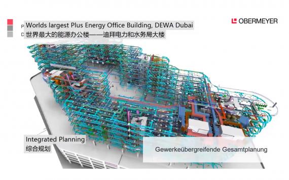
As already proven well in the previous year, OBERMEYER went on with his partners to represent the entire digitization chain in this industry. The guiding idea of the joint stand was draw a line from the digital planning of individual buildings to entire virtual city models including infrastructure. OBERMEYER presented executed projects of the entire range of services of the company featuring digital tools. BIM models were the focus of the interested stand visitors over all service phases in 3d/4D/5D and with a large number of successful implemented and partially innovative BIM use cases.
Markus Hochmuth, Head of BIM Infrastructure Department at OBERMEYER, also gave a lecture on the state-of-the-art for "Integration of BIM and 3D GIS Data". Using practical examples, he emphasized that it can create increasingly complex objects that contain a wide range of different information: about the building itself, about buildings in the immediate vicinity, over geological, geographical and demographic and socio-economic data. The main task is therefore to bring all this digital information together, to enable swift and comprehensive analysis, thus allowing the best conclusions in early stages for high project benefit.